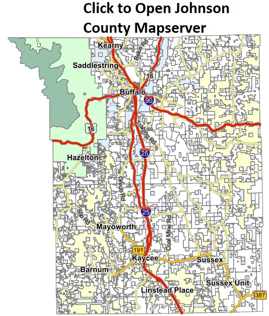
• Skip to primary navigation
  • Skip to main content
  • Skip to primary sidebar

Johnson County, Wy

Johnson County, Wy

MENUMENU
  • home
  • Departments
    • DEPARTMENTS

      Johnson County Government is comprised of various Elected County Offices and individual departments.   This section contains links to those offices and departments within the County Government structure.   Some departments maintain their own separate websites.

    • Assessor
    • Attorney
    • Building Facilities Manager
    • Clerk
    • Clerk of District Court
    • Commission Members
    • Coroner
    • County Agent
    • County Fire Warden
    • Emergency Mgmt / Homeland Security
    • GIS
    • Information Technology
    • Lake DeSmet Operating Department
    • Mikesell-Potts Recreation Area
    • Planning & Zoning
    • Public Health
    • Road & Bridge
    • Sanitarian
    • Sheriff
    • Treasurer
    • Rural Addressing System
  • Boards
    • Boards

      Board members are appointed by the County Commissioners.  Joint Powers Boards have both City and County members.  Board members elect their own officers and set their meeting schedules.  All Boards contain at least one County Commissioner serving as a member or liaison.

    • Airport Board
    • Board of Health
    • Buffalo Trails Board
    • Child Support Authority
    • Fair Board
    • Harold Jarrard Park
    • JC Community Juvenile Services JPB
    • Jim Gatchell Museum
    • Joint Powers Board – Justice Center
    • Kaycee-Buffalo-Johnson County Economic Development Joint Powers
    • Lake DeSmet Advisory Board
    • Library Board
    • Lodging Tax Joint Powers Board
    • Mountain Plains Heritage Park
    • Optional One Percent Sales Tax
    • Planning Commission
    • Predator Control Board
    • Recycling Center Joint Powers Board
    • Solid Waste Board
    • Johnson County Youth Camp
    • Volunteer Board Application
    • Sage Grouse Technical Team
  • COVID-19
  • Special Districts
    • Special Districts

      Special Districts are created either by Resolution of the Board of County Commissioners, by Petition of local landowners or by the State Board of Agriculture through a Petition of landowners.  All of the above require public notification and some may require a referendum.  The method of creation is  determined by the type of District.  WY Statute: 22-29-103

       Special District Board members are elected not appointed.  Ad Valorem Taxes may be levied for funding upon voter approval.

    • Cemetery District
    • Johnson County Fire District #1
    • Cancelled: Johnson County Healthcare Center Board Meeting 02.21.23
    • Johnson County School District #1
    • Clear Creek Conservation District
    • Powder River Conservation District
    • Powder River Fire District
    • Rural Health Care District
    • Senior Citizen Service District
    • Volunteer Board Application
    • Weed & Pest District
  • Links
  • Contact
  • Blog
You are here: Home / Departments and Elected Offices / GIS

GIS

What is GIS?

GIS is a Geographic Information System.  It integrates hardware, software, and data for capturing, managing, analyzing, and displaying all forms of geographically referenced information.

GIS allows us to view, understand, question, interpret, and visualize data in many ways that reveal relationships, patterns, and trends in the form of maps, globes, reports, and charts.

A GIS system is built with layers of data.  Some layers contain raster data (such as aerial photography) while others contain points, lines, polygons or text.  Most layers have an attribute table where the data for that layer is contained.  This attribute table can contain things such as name, address, acreage, length or any other pertinent information.

A GIS helps you answer questions and solve problems by looking at your data in a way that is quickly understood and easily shared.  GIS technology is used by governments, educators, scientists, military, conservationists, businesses, utilities and many others.

Jim Waller
County Planner
26 N DeSmet Ave
Buffalo, WY 82834
Phone: (307) 684-1907
Fax: (307) 684-2392
Email:  jwaller@nulljohnsoncowy.us 

Maps Available for Download or Viewing

  • Johnson County Mapserver (online map)
  • Johnson County Road Map Aug. 2020  (pdf format)
  • Buffalo TRAILS Pamphlet
  • Johnson County Voting Precinct Map (pdf format)
  • City of Buffalo Voting Precinct Map (pdf format)
  • Part VI – Zoning Map   (DRAFT ONLY)

To acquire local GIS data from Johnson County, contact the County Planner OR click the link below to download a GIS Request form.  All requests for data must be submitted to the County Planner.

Johnson County Wyoming GIS Request

Primary Sidebar

Planning & Zoning Links

  • Meetings
  • Planning & Zoning Documents
  • Planning & Zoning News
  • Rural Addressing System
  • Septic System Permitting
  • Natural Resource Management Plan (NRMP)
  • GIS

© 2023 Johnson County, Wy | Site by Vestor Logic